|
|
BANK
HOLIDAY HOLE
|
Various surveys on CaveMaps website
BANK HOLIDAY HOLE
NGR SD 6772 8057
A small cave located on the limestone bench on the east side of EASE GILL. The entrance is in a prominent shakehole, where a stream sinks, about 150m across LECK FELL from the entrance of SLIT SINKS and due south of THE BOREHOLE
A 2m entrance climb into a chamber leads to a hands and knees crawl for 25m to a flat out squeeze over cobbles. This breaks out into a 2m high rift passage developing into a winding stream canyon averaging 3-4m in height and 1m wide for 100m with some nice formations including a fine 2m long curtain. A small muddy inlet enters on the right and can be followed for 10m. The cave ends in a boulder collapse which is near to the surface and the resurgence, which is located on the limestone bench above the opposite bank to SLIT SINKS
See survey
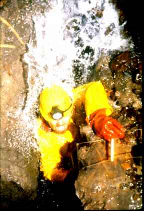
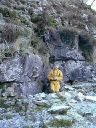
Photo: Pete Muckalt in Entrance of Bank Holiday Hole during its intial exploration. 1984.
|
 |
Situated in the true left bank of the gill, just downstream of the pool near Wretched Rabbit entrance, the hole is a narrow, wet and muddy sideways passage for 6 metres. Here a small inlet on the left emerges and just beyond is a widening where another inlet on the left is met. Ahead a small climb reaches a chamber, here to the left a roof inlet enters, straight ahead is a choked rift and to the right the passage is too tight. See photo
The entrance lies 91m upstream of MISTRAL HOLE behind a boulder against the scar on the true left bank of EASE GILL. It is partly obscured by landscaped digging material.
Short crawl into chamber with a floor of boulders separated by deep fissures. Bedding plane at the rear of the chamber continues as a dug out crawl. This continues low with a squeeze to a small boulder filled chamber. At the opposite end of the chamber is a tight slot and squeeze to another bedding plane crawl which breaks out into ATOLL CHAMBER a large flat roofed passage close to the HOBBIT in PIPPIKIN.
Stream sink in Oxford Cave Beck. Climb down 4m leads to a stream passage. Downstream is a wet crawl to a large white formation. Under this is a low bedding for about another 20 m to a tight rift. The water has been traced to Bat Cave. Upstream beyond a squeeze is a wide bedding, which has been pushed for 10 metres. It heads towards Oxford Cave 3
Small stream emerges from a rift entrance on true right bank of CASTERTON BECK. crawling leads to an awkward small chamber guarded by a duck. Branch on the right goes for 10m to a blockage where a waterfall can be heard, this water probably comes from the gill. The main cave continues as a hading rift for 15m until a low section is by passed on the left. A small stream emerges from a blockage at the end, the sink for this is in the quarry only 30m away.
Sutrface collapse into rift passage with way on blocked by surface debris.
The entrance is situated on a ledge in the cliff face on the south bank of EASE GILL opposite the tributary of HOWE GILL. A low dug craw passes a small inlet on right (too tight) and the way on continues as a flat out bedding to the head of a 5m pitch. A clean washed chamber at the base closes down to 100mm holes. The bedding continues above the pitch but is choked solid.
|
|
 |
1. An obvious bedding plane entrance across the gill from COUNTY POT The way on quickly lowers to a crawl and choked passages. Two other caves to the left and right of No.1 are short and choked with boulders. Length 8m
2. The entrance upstream of No.1 and higher in the scar. Stooping passage to a sudden entry into a fine chamber. A climb down overhanging blocks leads to the floor with several blind holes and a short passage, although one of the holes has been descended to a pitch with a very tight take off and no natural belay, down this leads to a rift which heads back under the gill, both directions are blocked by cobbles and boulders but a draft could be detected. Back at the chamber there is a climb up onto a shelf which has two inlets, One a narrow fissure, the other an easy going passage to a small aven. Length 33m
3. Immediately left of No.2 is a sideways slide into a high canyon and an easy traverse past a short side passage on the right to a boulder choke. Length 21m
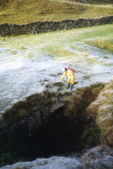
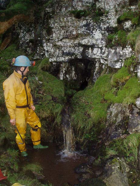
Cave in base of waterfall at Cow Dub is a short bedding plane cave in true right wall, only
accessible in extreme drought. See photo ![]()
COW DUBS II ![]() NGR SD 6749 8053
NGR SD 6749 8053![]() Alt 300m
Alt 300m
Length included in Ease Gill Caverns total
Entrance in rock walled hole just downstream on the left from COW DUBS waterfall itself. The hole leads to a flat out wet crawl to the head of a 3m drop. Below this a body sized tube , which can be extremely wet, is followed by more crawling to where the way enlarges to walking sized passage to a 5m pitch into the top of BUTTERFIELD'S PASSAGE in COUNTY POT
Entrance is is covered by boulders in a thick patch of bracken about 20m down the valley from where the wall joins the gill at COW DUBS, well up on the left bank near to a pointed boulder. A straight descent of 8m down the rift lands on a sloping floor which funnels down to a larger passage which quickly chokes in either direction.
FOX'S LAIR SD 67614 80665 Alt: 320m
Situated directly below BAT CAVE. Water falls into a nasty wet bedding plane which has been pushed under the gill to a low sump. In flood the water from here was seen to enter County Pot from the roof above Confusion Corner
This hole is situated in the North West face of a shakehole, 35 metres South East of Pool Sink and on the Leck Fell side of the gill. A squeeze down through boulders gives on to a small boulder floored rift down to a small chamber. A low arch in the left wall leads through to a junction. To the left chokes after 2 metres, whereas right enters a small chamber containing a high bedding inlet 2 metres up that becomes too tight.
.
Fissure in gill directly below the entrance to LINK POT Now filled in, if anyone wants some digging tools it is believed that the NPC left some at the bottom!!
HAZEL SIKE is the next gill north of AYGILL. Entrance is on the true right side of a small gorge below a dry waterfall. Pleasant hands and knees crawl to a small chamber with a dig in the floor.
Shaft by the track to HELLOT SCALES BARN (at present unstable at the top )is a straight 18m descent to a passage. Inlet to the northwest ,beyond a wet squeeze, ascends rapidly to become tight and choked. A small stream runs down the tunnel which chokes where the water sinks in a narrow fissure.
|
The shakehole with a drainage gully entering, on the opposite side of the track a few metres down from BULL POT of THE WITCHES. A straight 8m climb down leads to a small chamber and a loose boulder choke. At one time a passage through this led into CAVERN 32 in BULL POT of THE WITCHES |
Situated up the side valley above COW DUBS. Climb down into short passage and a further drop into a choked bedding cave, Blocked at present.
Situated down valley from lime kilns. Deep shakehole with cliff at back.Entrance on right of cliff-face,loose rock on right wall. Climb down shoring leads to dig Climb down narrow rift for 7 metres to iron ladder. At present being dug in rift continuation.
Situated in a large shakehole between CASTERTON POT and AYGILL. Fissure descends to a squeeze under the right wall and loose debris slope into a loose chamber from which a short passage descends to a hole in the floor with a choked crawl below. All a bit loose!
Eleven small caves all situated by the LOWER
EASE GILL KIRK, with No's 1-7 being in the true left bank of the
gill, and described going upstream, whilst No's 8-11 are in the
opposite bank and are described going downstream. See original 1930's
survey.![]()
1. 30m before the obvious cave in the rocky banking below a grass slope. A small passage giving awkward sideways crawling to where a calcite false floor blocks the way on. Length 8m
2. In the main rocky cove low down. A short choked muddy crawl.Length 5m
3. Larger entrance close to No.2 and above it. An ascending tube ends at a calcited choke. Length 8m
4. 5m beyond No.3 and low down. Muddy hands and knees crawl to a step up to a 'T' junction. Both ways quickly close down. Length 12m
5. NGR 6612 7996. (Alt:237.) Reached by a climb up the rock wall. A straight 10m phreatic passage. The walls are covered with a powdery stalagmite deposit, and the way on is blocked by a boulder blockage at floor level. The small passage above has a dubious climb with loose boulders.
6. NGR 6612 7996. (Alt:241.) Directly above No.5 A 5m ladder is required to reach the entrance from the top of the scar.A large phreatic rift passage ends in a sand and mud choke. Has been dug. Length 6m
7. Obvious opening in the left bank at the foot of the waterfall leads to a chamber. To the right pinches out, whilst to the left an easy climb up a series of steps leads to another entrance above the waterfall. Length 8m
8. Below the waterfall in the right bank is a rift entrance which quickly reaches where the way on is choked with silt. Length 5m
9. Large open rift which can be followed to a dig in a small tube. Length 12m
10. Directly above No.9 about 10m above ground level, the entrance can only be entered by a pendulum into the awkward shaped entrance. A slippery phreatic tube which ascends to a choke. Length 8m
11. This is situated in the the wall opposite No.1 and is reached by a dangerous climb up peeling blocks.A stooping size passage leads to an over tight inclined bedding passage beyond the initial squeeze, whilst to the right and low down is another squeeze into a small chamber. Several small openings lead off, but all are impassibly tight. Length 18m
Situated in a large shakehole 40m south of the stream sink close to the wall.A timbered shaft entered a small draughting chamber which has now collapsed.
Situated in a large gully up on the left bank just downstream from LINK POT Narrow rift entrance leads to a 9m pitch down to a small chamber and a pool.
Entrance located just upstream and on the opposite bank to SWINDON HOLE A drop down into a short section of rift leads to a calcite choke and a low wet bedding plane leading off at the base which becomes too tight.
Entrance lies 137m downstream of HOWGILL SINK in boulders at the foot of the bank 14m from the gill. 6m pitch into a rift leads to a short tight crawl through to a small chamber with a boulder floor.
A series of caves associated with the tributary gill opposite OXFORD POT
1NGR SD 6756 8058 Alt 317m. Entrances are situated 15 metres downstream from Gelder Hole. At gill level water can be heard through the lower entrance, a bedding slot under the cliff on the left bank. The easier(!) entrance is an easily missed rift on a grassy ledge 10 metres above. Downstream, currently choked, soon leads back to the rising below. Upstream, a tight squeeze in a narrow canyon soon raises on a tight bend into a small bedding. Then, awkward going over pools and cobble obstacles as the passage narrows, leads after 22m to a choke. 6 metres back from the choke a strong draught enters from the left (looking downstream) through rocks choking a tiny inlet. This is likely to be the entrance below a crumbly scar in a small pit just below Oxford Cave II. Length 24m
2. NGR SD 6756 8056. Alt 317m. Situated below the prominent scar in bedded limestone. A wriggle through onto wider passage where stream sinks in the floor. Upstream is a pleasant crawl to a series of impassable choked inlets below the surface stream bed. Length 46m
3. NGR SD 6762 8052 . Alt 333m. Entrance is up the gill on the right beneath a covered manhole. A climb down to a 'T' shaped passage leads to a chamber and a further twisting passage which develops into a tortuous traverse. Length 21m. Stream can be heard at end.
Situated about 30m southwest of the BOUNDARY POT On the same side of the gill and 40 metres downstream of Boundary Pot entrance, this cave lies in a shallow trench-like shakehole, on a bench 15 metres from the centre of the gill. A 3 metre descent through boulders to a small chamber, here a slope to the left leads to the stream as it disappears into a bedding, possibly to emerge in Boundary Pot. Ahead a short, tight narrow passage forced at floor level, enters a small aven with water issuing from a tiny inlet in the roof. The water runs off back through a bedding toward the entrance and the way on ahead in the aven is choked.
POT BLACK (Boulder Pot)Explored by RRCPC 1980. Excavated hole in shallow shakehole 275m SW of Pippikin wall. Climb down with care past acrow sremple and slide through boulders to squeeze between blocks and further climb downonto rubble slope into small chamber. 8m pitch lead to short rift and another undescended drop . Top of pitch now collapsed.
Situated about 40m southwest of the BOUNDARY POT eyehole.
A piece of rebar rod is used for a ladder belay to descend the 4 metre pot. At the base, a drop into a bedding heads left, while a too tight hole in the floor drops away below. The bedding crawl continues and trends back into the hillside to choke after only 4 metres.
The entrance has collapsed and at present the actual position is undetermined, Prominent rift in scar by EASE GILL. Letterbox entry shaft to a tight section followed by easy going leads to the KEYHOLE and a wide passage. After a few metres debris reaches nearly to the roof near a boulder choke in UPPER 'T' PIECE PASSAGE in POOL SINK Blocked at present.
This small entrance is near the top of a slight outcrop, on the slope, 20 metres due East of Wretched Rabbit entrance. A squeeze down through boulders lands in a small stream as it continues through the choke to resurge further down the slope. Upstream continues as a crawl over cobbles until after 8 metres the cave develops into a large bedding plane and the stream splits into two, barely separate branches. The right branch has a small leg off to the right but the bedding ahead slowly becomes too low after 10 metres. The left branch gradually widens out and also closes down after 10 metres.
 |
SHEEPFOLD CAVE Situated at the back of the prominent sheepfold upstream of and on the opposite bank of SWINDON HOLE . A dry crawl to the stream in a 1.2m high passage to a junction. Right is sideways going for 18m to a shingle choke. To the left is an inlet, which is an awkward struggle to a small waterfall where it was possible to emerge beneath a huge boulder at the sink higher up the fell (Now blocked). |
ST GEORGE'S CAVE![]() NGR SD 6770 8072
NGR SD 6770 8072![]() Alt 323m
Alt 323m![]() Length 6m
Length 6m
This small cave is entered through a low arch almost opposite but slightly upstream of The Borehole. Above the entrance crawl is a small choked aven but the passage ahead chokes almost immediately to the right in a clay and cobble wall and to the left is a boulder filled slot in the floor. The slot obviously takes water when the gill flows and may connect to inlets in The Borehole.
Situated in shallow dry valley between end of Bullpot Farm Lane and green lane to Barbondale on line of Dent Fault. Entrance covered with tin sheet
On the left bank of Leck Beck 91m downstream of LECK BECK HEAD on the limestone shelf. A short oxbow with a narrow active inlet.