NOTES ON THE EARLY INVESTIGATIONS ON
CASTERTON AND LECK FELL
by Andy Hall
Although the heyday of discoveries in the Lancaster-Ease Gill
System began in 1946, exploration of the area commenced in the late
19th century by the Yorkshire Ramblers Club. They became aware of the
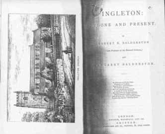
importance of the area by earlier references, such as "Ingleton,
Bygone & Present" by Robert R. and Margaret Balderston published
in 1888. This book describes the geography of the area and the
following extract describes what was known at the time of their
visit.
|
Following the next wall to the south west from Gravel Pot
downwards, so as to reach the Ease Gill Beck, where are the
Witches' Caves, the Kirk, and other places already
described, and ascending a small stream that is the direct
continuation of the Leck Beck, and does not bend away like
Ease Gill, a walk of about three-quarters of a mile along
this little valley, bring the tourist to Bull Pot in the
very centre of the hollow, a trifle below the last farm
house in this direction, and only a field's breadth from the
road running along Casterton Fell. Bull Pot is a dreadful
hole, foetid with the dead carcasses of sheep and lambs, and
whitened with skeletons. A vast cave-like mouth to be seen
in the base of its north western side, a waterfall
precipitates itself downwards to the extent of fifty-eight
feet, though when the water is low its principle leap is
diminished to forty-five with a secondary cascade below. The
rock to the south is fifty-four feet high, that on the west,
though not sheer at the top, is eighty-five feet whilst the
hole itself measured round its neck of entrance is about
seventy-seven yards.
|
COW POT. Only a couple of fields' breadths to the east of Bull Pot in
the course of a diminutive stream is a peculiar zig-zag sided rift
called Cow Pot, into which the brook descends as a fall for thirty
feet, with a second leap of twenty more and a third not easily
described beyond; the full depth at the lower end being seventy seven
feet. The character of the rock work is beautiful and exquisite ferns
deck the crevices.
Witches Cave and the caves of Lower Ease Gill were also explored and
recorded by Balderston in his quest for archaeological sites.
However, little of archaeological interest was found.
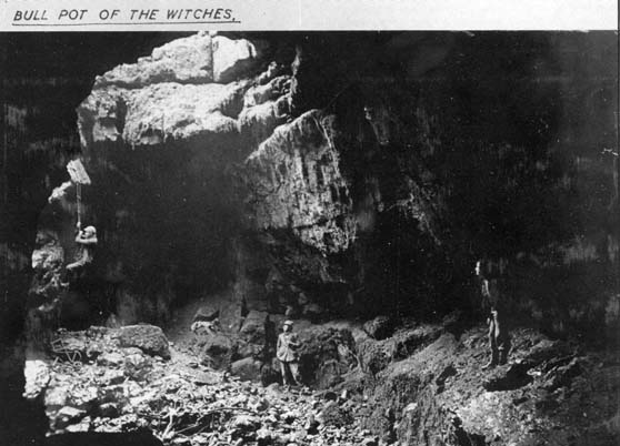
BULL POT OF THE WITCHES
|
The Yorkshire Ramblers Club became active in the late
1880's and are well known for their descents of Gaping Gill
but they were in fact exploring right across the Dales. In
1899 YRC visited Casterton Fell and explored Bull Pot of the
Witches and Cow Pot (Anon, 1900). Bull Pot of the Witches
was so named, not so much as having been associated with
witches but rather to distinguish it from Bull Pot in
Kingsdale and its proximity to Witches Cave. This well known
cave lies just to the south of Bull Pot Farm and can now be
descended down to its downstream sump over 200ft below
without any tackle if care is taken. The trees which
surround the hole give it a picturesque setting and they
must have done so in 1899 when there were even more of them.
A good sized stream having its source in the enclosure north
of the farm, falls down an impressive waterfall into the
open pot some 50ft below.
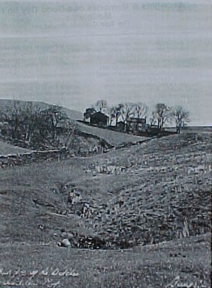
Bull Pot of the Witches and Bull Pot Farm in April
1932. Photo taken by Eli Simpson and Re-produced from the
B.S.A. Records now held in the B.C.R.A Library.
|
The first recorded descent appears to have taken place on
22nd May 1899 (Anon, 1900) by YRC members S.W. Curtriss, W. Parsons
and J.W. Swithenbank who reported the hole to be 210ft deep. After
that time several explorations took place but no complete survey was
attempted until 1932. During the course of this work an inscription
was noted by Eli Simpson in Long Gallery.
BONES April 11 th 1909
A.M.
B.B. K.B. G.D. T.B.
This was interpreted as having been made by Mr. T.R. Burnett who was
Head Master at the Kirkby Lonsdale Grammar School and did much
exploration in the cave between 1909-1912 including the discovery of
Burnett's Great Cavern. In 1919 Hastings and Hudson from YRC drew up
a rough survey and reexplored Long Gallery and Burnett's Cavern
(Anon, 1927). Later explorations in March 1926 by YRC led by E.E.
Roberts, their President discovered Robert's Passage. This provided a
route between upstream and downstream Bull Pot by-passing the
downstream pitches.
|
In April and May of 1932 five visits were made by Eli
Simpson, Miss M. Greenwood, Messrs. E. Clarkson, W. Fairbank
and S. Waller to explore, survey and photograph the known
cave and their discoveries. These included 1932 Cavern and
the connection to Hidden Pot which lies just to the south of
Bull Pot. Clarkson's Pot and Crawl were also explored.
Hidden Pot had been discovered by YRC in 1926 and was not
known to the local farmer as it had been covered by
brushwood.
|
.
COW POT
The first recorded descent of Cow Pot was also on 22nd of May 1899
by Cuttris's, Parsons, Swithenbank and G.T. Lowe (Anon, 1900).
However, Simpson recorded an inscription on the wall below the
entrance pitch in Shale Cavern. "A. Moorhouse 1736". Whether this
person did descend in the year stated or it is a false inscription we
shall never know. The YRC found Cow Pot to be 100ft deep with several
crawls and a large cavern on a shale band at the bottom. In 1932
Simpson and the BSA carried out an accurate survey and he made this
note in his personal records. "The water probably flows to Leck Beck
Head though this has not been tested. If this is the case then the
differences in elevation between the lowest point in Cow Pot and the
issues indicate possibilities of still further exploration."
Early Leck Fell Explorations
Peterson, Pippikin and Nippikin Pots appear to have been first
explored by members of the Gritstone Club during Whitsuntide 1929.
Extracts from the Gritstone Journal, Volume 3, Number 3, of the time
are given here to give some idea of the spirit of exploration
prevailing at the time.
Leck Fell at Whitsuntide was a congested area. Ardent young potholers
were swarming round all the principle pots, and we regarded the
prospect of joining the queues for Deaths Head or Lost Johns with
some dismay.
Wood came to the rescue with a memory of potholes stumbled across in
the dim past, somewhere near Ease Gill Kirk. To our surprise, he was
able to find them again, and on this virgin field we decided to
expend our energies. They proved to be small but well found pots.
They lie close together and near the next wall parallel to, and North
of that passing between Gavel and Deaths Head pots, in a general
northerly direction from the latter, and much lower down the fell
side towards Ease Gill.
PETERSON POT. The first explored, lies in a series of large sinks on
the near (SW) side of the wall and marked by a rowan tree. Wood, who
found it, insists it shall be known as Peterson Pot in memory of a
cherished pipe he left behind him in it. It has two pitches and with
good measure for the depth of the sink, can be estimated at 70ft. The
quest of the pipe finally abandoned, Wood led us over the wall to
view the remainder of his properties.
NIPPIKIN POT. These are situated in a line of sinks parallel with the
wall, and about a hundred yards from it. An obvious shaft, marked
only by a small tree, at the lower end of the depression, was choked
at depth of 40ft, but a small fissure in the rock wall to the SW,
proved to have far greater possibilities. The first descent was made
by sundry large stones on Saturday evening and with the resultant
crashing and booming singing pleasantly in our ears, we strolled back
to camp. The fine weather held, and on the following morning, the
potholers labourers were seen at work.
PIPPIKIN POT. On emerging into daylight, we remembered the Sabbath, a
dolch for niente feeling crept over the party, and with silent
unanimity we trickled back to the flesh pots of the camp. (A.M.T. was
among those present. )
Work was resumed on Monday, when we descended a promising opening
higher up the line of sinks and a little below the entry of a tiny
stream. This is one of the possible entrances to a fairly wide shaft
about 20ft deep. A stream passage of ample width but whose height was
a matter of inches, was followed for eight laborious yards to the
north-west, where to our relief a fissure cuts across at right angles
and broadens below and to the left into a respectable shaft.
After dislodging a jammed stone from the intersection of bedding cave
and fissure, we succeeded in passing a ladder through the cave and
shoals and down the shaft. By a nice manoeuvre, the leading labourer
succeeded in translating himself from the horizontal to the vertical
plane, renewing acquaintance with the jammed stone a few feet down
the shaft. It was poised on a smaller natural bracket on the wall of
the shaft and could not again be pushed off, for fear of damaging the
ladders below. It made an emphatic nuisance of itself. The pitch
proved to be one about 40ft, the shaft being curiously divided about
a third of the way down into a trousers-like formation by a
knife-edged flake (Cellar Pot).
These pots were explored in April 1934 when Messrs. K. Appleton, P.
Binns and E. Simpson made a survey of Pippikin and Nippikin. Simpson
in the BSA records concluded with these prophetic words. "The area is
most interesting and should yield further discoveries to careful
examination." 
RRCPC 2005